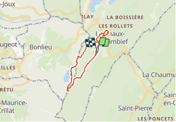
![](/images/other/stat-length.png)
![Tour Wandern La Chaux-du-Dombief - Le sentier des Cairns et lac de Bonlieu avec belvédères - Photo](https://media.geolcdn.com/t/1900/400/ext.pjpeg?maxdim=2&url=https%3A%2F%2Fstatic1.geolcdn.com%2Fsiteimages%2Fupload%2Ffiles%2F1553511878bg_sport_marche.png)
Le sentier des Cairns et lac de Bonlieu avec belvédères
daniellebou
Benutzer
![Länge](/images/other/stat-length.png)
![Maximale Höhe](https://static1.geolcdn.com/siteimages/upload/files/1508320355ic_sort_altitude_max_24dp.png)
![Positive Höhendifferenz](https://static1.geolcdn.com/siteimages/upload/files/1508320355ic_sort_den_pos_24dp.png)
![Km-Effort](/images/other/stat-length.png)
![Min. Höhe](https://static1.geolcdn.com/siteimages/upload/files/1508320355ic_sort_altitude_min_24dp.png)
![Negative Höhendifferenz](https://static1.geolcdn.com/siteimages/upload/files/1508320355ic_sort_den_neg_24dp.png)
![Boucle](https://static1.geolcdn.com/siteimages/upload/files/16400158638029165_repeat_loop_refresh_sync_direction_icon.png)
![Wandern](https://static1.geolcdn.com/sitytour/trail-icons/101.png)
3h43
Schwierigkeit : Schwierig
![Scannen Sie diesen QR-Code, um die Tour in der SityTrail-Anwendung zu öffnen](https://capi.geolives.com/qq0zvz2zws4bq2lad0pu/sitytour/trails/2912774/qr.png?size=200)
Kostenlosegpshiking-Anwendung
Über SityTrail
Tour Wandern von 11,2 km verfügbar auf Burgund und Freigrafschaft, Jura, La Chaux-du-Dombief. Diese Tour wird von daniellebou vorgeschlagen.
Beschreibung
A la fin du sentier des Cairns, suivre balisage bleu et vert (ronds) et ensuite balisage vert jusqu'au lac de Bonlieu. Beaucoup de chemins dans les bois sur le terrain ne figurent pas sur la carte donc il est important de bien suivre le balisage vert jusqu'au lac de Bonlieu qu'on quitte ensuite.
Ort
Kommentare
Touren in der Umgebung
![Tour Wandern Le Frasnois - Cascades du Hérisson et les 4 lacs - Photo](https://media.geolcdn.com/t/375/260/21e4ab88-25e9-4626-96ca-824b99d2ef38.jpg&format=jpg&maxdim=2)
![Wandern Wandern](https://static1.geolcdn.com/sitytour/trail-icons/101.png)
Wandern
![](/images/other/stat-length.png)
![](https://static1.geolcdn.com/siteimages/upload/files/16400158638029165_repeat_loop_refresh_sync_direction_icon.png)
![Tour Wandern Menétrux-en-Joux - Cascades du Hérisson 13.7.24 - Photo](https://media.geolcdn.com/t/375/260/69d09d5d-3655-46aa-9437-84eed487569c.jpg&format=jpg&maxdim=2)
![Wandern Wandern](https://static1.geolcdn.com/sitytour/trail-icons/101.png)
Wandern
![](/images/other/stat-length.png)
![](https://static1.geolcdn.com/siteimages/upload/files/16400158638029165_repeat_loop_refresh_sync_direction_icon.png)
![Tour Wandern Le Frasnois - Lac de Narlay - Pic de l'Aigle - Photo](https://media.geolcdn.com/t/375/260/b7a3f0c8-5d9b-454f-b8e6-bb75ea28ecff.jpg&format=jpg&maxdim=2)
![Wandern Wandern](https://static1.geolcdn.com/sitytour/trail-icons/101.png)
Wandern
![](/images/other/stat-length.png)
![](https://static1.geolcdn.com/siteimages/upload/files/16400158638029165_repeat_loop_refresh_sync_direction_icon.png)
![Tour Wandern Le Frasnois - lacs des maclut - Photo](https://media.geolcdn.com/t/375/260/ext.jpg?maxdim=2&url=https%3A%2F%2Fstatic1.geolcdn.com%2Fsiteimages%2Fupload%2Ffiles%2F1553511878bg_sport_marche.png)
![Wandern Wandern](https://static1.geolcdn.com/sitytour/trail-icons/101.png)
Wandern
![](/images/other/stat-length.png)
![](https://static1.geolcdn.com/siteimages/upload/files/16400158638029165_repeat_loop_refresh_sync_direction_icon.png)
![Tour Wandern La Chaux-du-Dombief - pic de l''aigle - la Chaux-du-Dombief - Photo](https://media.geolcdn.com/t/375/260/ext.jpg?maxdim=2&url=https%3A%2F%2Fstatic1.geolcdn.com%2Fsiteimages%2Fupload%2Ffiles%2F1553511878bg_sport_marche.png)
![Wandern Wandern](https://static1.geolcdn.com/sitytour/trail-icons/101.png)
Wandern
![](/images/other/stat-length.png)
![](https://static1.geolcdn.com/siteimages/upload/files/16400158638029165_repeat_loop_refresh_sync_direction_icon.png)
![Tour Wandern La Chaux-du-Dombief - Pic de l'Aigle - Photo](https://media.geolcdn.com/t/375/260/c203af9d-fb05-4002-9a9b-9cbbb8532a26.jpg&format=jpg&maxdim=2)
![Wandern Wandern](https://static1.geolcdn.com/sitytour/trail-icons/101.png)
Wandern
![](/images/other/stat-length.png)
![](https://static1.geolcdn.com/siteimages/upload/files/16400158638029165_repeat_loop_refresh_sync_direction_icon.png)
![Tour Wandern Le Frasnois - La Fromagerie - Photo](https://media.geolcdn.com/t/375/260/8bf2dd93-4fc0-4bb5-bd59-9d9720fff72b.jpg&format=jpg&maxdim=2)
![Wandern Wandern](https://static1.geolcdn.com/sitytour/trail-icons/101.png)
Wandern
![](/images/other/stat-length.png)
![](https://static1.geolcdn.com/siteimages/upload/files/16400158638029165_repeat_loop_refresh_sync_direction_icon.png)
![Tour Wandern Le Frasnois - Pic de l'Aigle 14.7.24 - Photo](https://media.geolcdn.com/t/375/260/0d4fe3bb-0e43-456c-9601-a5aa0df2bf07.jpg&format=jpg&maxdim=2)
![Wandern Wandern](https://static1.geolcdn.com/sitytour/trail-icons/101.png)
Wandern
![](/images/other/stat-length.png)
![](https://static1.geolcdn.com/siteimages/upload/files/16400158638029165_repeat_loop_refresh_sync_direction_icon.png)
![Tour Reiten Le Frasnois - suuntoapp-HorsebackRiding-2024-05-22T07-07-14Z - Photo](https://media.geolcdn.com/t/375/260/02cd052f-9d06-4d04-8797-8cfd020cca6b.jpg&format=jpg&maxdim=2)
![Reiten Reiten](https://static1.geolcdn.com/sitytour/trail-icons/301.png)
Reiten
![](/images/other/stat-length.png)
![](https://static1.geolcdn.com/siteimages/upload/files/16400158638029165_repeat_loop_refresh_sync_direction_icon.png)